
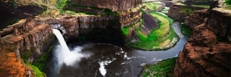
News » Palouse Falls
Palouse Falls Designated Official State Waterfall
After six months of hard work and determination, third through sixth grade students in the Washtucna School District, pushed through a bill that made Palouse Falls the state waterfall. Last fall, the students made a field trip to the falls, and inspiration struck. Soon after, joined by Rep. Joe Schmick, R-Colfax, they started lobbying to get the bill passed. Five students travelled to Olympia to testify in front of a house committee.
On Tuesday, March 18th, Governor Jay Inslee arrived at Palouse Falls to officially sign the bill and declare it the state waterfall. This designation could mean more tourists to the area, adding to the approximately 100,000 visitors per year to the park.
Third grader, Cooper Jessop (son of Stephanie Jessop, of our Safety Department) received a special honor. Because Cooper was the youngest in his class, Governor Inslee named him Washingtonian of the Day” and presented him with a pin. “It was really exciting for me, one of the biggest things to happen.” Cooper said of the day.
Alex McGregor submitted a letter to the legislature in support of House Bill 2119 Designating Palouse Falls as Washington's State Waterfall. In it he provides the historical significance of what has been deemed "the crown jewel of the Palouse River canyon." An excerpt from that letter is below...
Palouse Falls was created by floodwaters from glacial Lake Missoula, a massive onslaught of water equal in volume to more than ten times the volume of all the rivers in the world today. The lake, impounded by a giant ice dam, was two thousand feet deep in places and contained a volume of water equal to that of Lake Ontario and Lake Erie today. When the dam failed, a flood that lasted little more than a week carved the Channeled Scablands across wide swaths of eastern Washington, created a new channel for the Palouse River, and gouged out the falls. More floods followed—a remarkable story of a spectacular process that occurred just yesterday—12,000 to 15,000 years ago—in geological terms. When NASA scientists studied a huge flood that once occurred on Mars, they came to Washtucna, for here was the place on this planet that came closest to matching the scale of the massive Martian event.
Though the story had long been known to geologists and local residents and a few others, in the past decade people from around the state, nation, and world have come to realize the remarkable evidence of this spectacular geologic series of events. The Ice Age Floods Institute today generates much interest in that geologic past and Washtucna resident Lloyd Stoess takes many of its members on walking tours of the rugged river canyon of the scenic lower Palouse. The Washington State Parks agency has in its custody a 130-mile long rail bed trail that crosses much of the rugged scabland country created by the Lake Missoula floodwaters. Many who visit that park trail learn about Palouse Falls, several miles further east, and go there to see the dramatic active waterfall that vividly illustrates the scenic canyons created by the cataclysmic floods of our recent geologic past.
We do not know for certain yet if Native Americans were here to witness the cataclysms that created Palouse Falls and the Scablands. The number of legends about giant floods told by tribes across eastern Washington and along the Columbia is striking. Three generations of my family heard the story of the ‘Big Falls’ from Sam Fisher, a Palouse Indian friend and neighbor, and my cousin committed it to paper in 1936. Four giant brothers and their giant sister, Sam told them, took great pride in keeping their hair shiny and decided to get more oil to keep their locks fashionable by attacking the huge big Beaver that lived nearby to get oil from his tail. They battled for miles and miles, Sam’s rendition of the battle explaining every feature of the river, the three upper waterfalls representing places where he slapped his tail and the 198 foot Palouse Falls, where Beaver fought valiantly and tore out a huge canyon, the place where his claw marks (geologists consider them vertical cracks in the basalt formations) are visible today. He’d have escaped had not Coyote spied him and sung his Power Song and convinced him to go back upriver to the Big Falls where the giant brothers and their sister killed him. A big rock at the confluence of the rivers was his heart and was named Palus, after which their village and ultimately the region were named.
Meriwether Lewis and William Clark visited Palus, the nearby village downriver, in 1805, where as many as fifty mat covered lodges were occupied seasonally when the Palouse came to fish for salmon. There they presented a Jefferson Peace Medallion to one of the Palouse chiefs, a medal that was found by archaeologists in 1964. Archaeologists from Washington State University found, at that village site, what were then described as the oldest human remains on the continent. Many an explorer followed Lewis and Clark and took note of the country. Artist Paul Kane, who sketched Palouse Falls in 1847, described the area as “a curious and strange region….that assumed a new aspect of increased wildness and magnificence at every turn.” John Mix Stanley also visited the falls that year—his sketch of Palouse Falls (from the book Eye of the Explorer by Paul McDermott, Ronald Grim, and Phillip Mobley) is attached. Washington Territorial Governor Isaac Ingalls Stevens told another version of the origin of the falls after his Pacific Railroad Survey in 1855—the Palouse Indians had told him the falls were created by the Great Spirit to keep salmon from ascending the river further upstream as a punishment for wicked Indians who lived there. Whatever its origin, the big falls has attracted visitors to the remote lands for generations. I’ve attached a photo of a couple of visitors to Palouse Falls, circa 1920, from the Anne Pierce Aslin collection of the Whitman County Library.
Palouse Falls and its canyon today remain unchanged and pristine. The wagon ruts of the Mullan Road, built in 1861 to connect Fort Walla Walla and the Columbia River with Fort Benton and the Missouri in Montana, along which thousands of miners and mule packers traveled from gold fields to the town built to serve them, the largest city in the territory—Walla Walla—are visible nearby. The ruts of wagons brought by Colonel George Wright and his troops in their punitive mission to punish the Indians after Lieut. Col. Steptoe’s defeat are visible in a nearby canyon and across the prairies adjacent are several Indian trails visible to a discerning viewer. The faded sign indicating the route to Palouse Falls dating back to the early twenties still stands, its AAA designation slowly fading, in my family’s livestock range nearby.
In his biography of the geologist who spent his career convincing colleagues of the great flood (Bretz’s Flood: The Remarkable Story of a Rebel Geologist and the World’s Greatest Flood), John Soennichsen says “the canyon that leads from the falls to the Snake River is so deep and impressive as to render the first-time visitor speechless.” Geologist Bruce Bjornstad (On the Trail of the Ice Age Floods) references “spectacular Palouse Falls,” “the crown jewel of the Palouse River canyon.”
In the recent Top 10 USA Waterfalls List, the authors mention “the regal Palouse Falls in the remote southeast region of the state,” which they “liked so much that we have made room for it on our Top 10 USA Waterfalls List.” Dan Nelson and Alan Bauer, in Best Desert Hikes: Washington give a description of the spectacular nature of the falls: “Its size and splendor make Palouse Falls one of the most scenic and impressive waterfalls….but its location adds even more magic and wonder to its image. The falls can’t be seen until you are nearly on top of it, but then—wow!...the thundering waters of Palouse Falls pounding 198 feet into a circular bowl carved out of the cinder black rock..”